
Crater(s) >
Intermontane Crater >
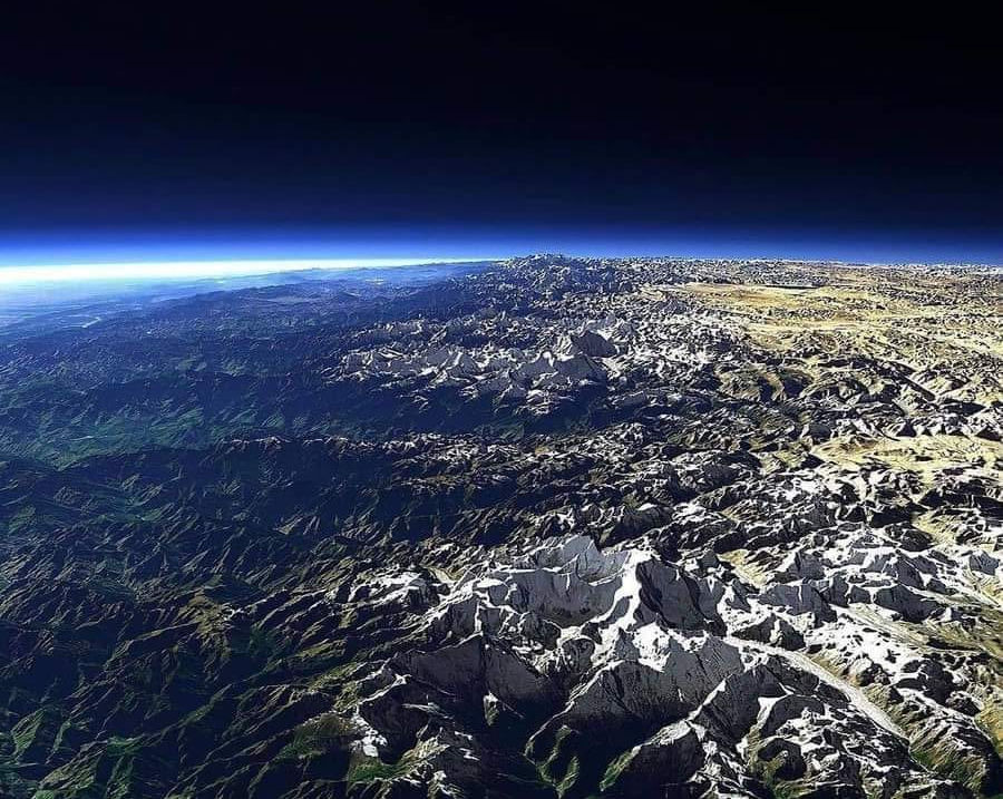
Space shuttle over the Himalayan Mountains.
You are looking at the rim of the world's largest visible crater remnant. One of the planet accretion builders. Wow! Notice the rim is fractal cones, these are not shatter cones which are made by a harmonic. They are up splash points.
.jpg)
Tectonic push encounters previous large crater.
Type 2 Subduction Crater
So here is an article recently published by geologist who are still clueless.
https://www.sciencedaily.com/releases/2020/09/200922144312.htm?fbclid=IwAR15mTbQ-GYC-RAr7LyAPT9bpctJDNhZGQFLkOwuNfdKZviTdG_0PAnUDPI
As you can't get most people to read them I make it my business to translate what's important to know from them. First their unsaid fundamental assumption is incorrect. Crashing tectonic plates will never make a circle arc. I mean you can do that experiment a million times yourself. Only if the crashing plate is circular will that happen which is metal forming process is called a ram. But if you now have an arc circle ram that is another unresolvable as to why is it an arc circle ram. On the other hand with impact you have all the features and mechanics to make a strong forensic physics case. Going from there, a logical conclusion is an earth accretion type large crater rim is still exposed and the tectonic phenomena are secondary physics processes as that type of impact would connect below the crust.

Impactite from Rolpa Nepal with constellationing shown in circle. Manganese and iron provides the color.

Scientists Find Half-Billion-Year-Old Ancestral Mountains In The Himalaya
Date:
October 6, 2003
Source:
University Of Arizona
Summary:
The world's highest and most spectacular mountains, the Himalaya of Nepal, India, and Bhutan, are built on the foundations of a much older mountain system, University of Arizona geoscientists have discovered.
Share:
FULL STORY
The world's highest and most spectacular mountains, the Himalaya of Nepal, India, and Bhutan, are built on the foundations of a much older mountain system, University of Arizona geoscientists have discovered.
They have dated rocks that show Earth's mightiest range is predated by ancestral mountains that existed in the same area between 450 million and 500 million years ago, long before India began plowing northward into Asia 55 million years ago.
Their findings not only revise ideas on the region's tectonic history, they offer new insight on connections between uplift of the Himalaya during the past 55 million years and simultaneous global shifts in seawater chemistry and climate.
"We conclude that the modern Himalaya Mountains are built on the foundations of an ancient mountain range that may have been of similar dimensions," said UA geosciences Professor George Gehrels, who used state-of-the-art radioisotope techniques to date rock formations in the Himalayan thrust belt.
Gehrels, UA geosciences Professor Peter G. DeCelles, UA doctoral candidate Aaron Martin, UA master's degree graduate Tank Ojha, UA undergraduate geosciences major Guy Pinhassi, and geology Professor Bishal Upreti of Tribhuvan University in Kathmandu, Nepal, have collaborated in field expeditions in rugged areas of Nepal for the past several years. They report on their research in the September issue of GSA Today, a scientific journal of the Geological Society of America, online at http://www.geosociety.orgTank Ojha (left), a UA master's degree student who now runs a geo-trekking company in Kathmandu, and Tribhuvan University geology Professor Bishal Upreti here debate the origin of boulder-borne schist from the high Himalaya.
"Our model is based on observations that, between 450 and 500 million years ago, rocks in the Himalaya were pushed down to great depth and metamorphosed," Gehrels said.
The buried rocks became so hot under great pressure that they melted, producing large granite bodies. The metamorphic schists and granite bodies contained garnets and zircon crystals that Gehrels dated to around 500 million years using uranium-lead radioisotope techniques.
These deep-level rocks were brought back up to the surface by processes of faulting, uplift, and erosion soon after burial, their observations suggest. The processes of uplift and faulting formed mountains, which eroded and produced huge volumes of sediment.
The scientists studied conglomerates and sandstones found in these "ancestral Himalaya" sediments in many different areas of the present-day range. Their main area of research, in the Annapurna range of Nepal, is a 5-day walk from the end of the nearest road.
They hired porters to carry camp gear and field equipment. Because most samples weighed around 5 kilograms (11 pounds) and were collected many miles from the nearest road, the researchers processed their samples in the field, crushing granite samples by hand and extracting garnets and zircon crystals by the panning-for-gold method.
The Himalaya is the best place on the planet for studying what happens when Earth's continents collide, Gehrels noted.
Earth's surface is covered by a series of tectonic plates. Heat from deep within the Earth drives convection currents that move the plates in different directions. India rides on a plate that steadily advances north a couple of centimeters a year, about as fast as your fingernails grow. During the past 55 million years, this action has uplifted Earth's tallest mountains, capped by 29,000-foot-plus Mount Everest.
"The birth of the Himalaya is indeed this great story of rocks being shoved down and being brought to the surface, while huge amounts of erosion take place. But we now think that much of the burial, uplift, and erosion happened between 450 million and 500 million years ago," Gehrels said. "The ancestral Himalaya Mountains appear to also have formed in a regime of continental collision, with the Indian continent being shoved beneath another landmass."
However, WHICH landmass is not yet known, he said.
"According to our model, this collisional event began with a small range forming at around 508 million years ago. The faulting, burial of rocks, formation of granite bodies, and uplift then propagated toward India through time, with the mountain range growing in width and perhaps elevation," Gehrels said.
By about 450 million years ago, as the forces of mountain building waned, erosion leveled the topography down to the deep-level metamorphic rocks, generating enormous amounts of sediment. Subsequently, the ancestral Himalaya Mountains disappeared and the region eventually subsided below sea level as the landmass was rifted away from India's northern margin, Gehrels said.
"The region remained buried below marine sediments until India collided with southern Asia around 55 million years ago and the modern Himalaya Mountains began to form," he added. More research is needed to determine the relative proportions of faulting, burial, metamorphism, generation of granites, uplift and erosion that occurred during these two phases of mountain-building, he said.
The revised geologic history also challenges Earth scientists to rethink ideas on global climate change and the global shift in seawater chemistry of about 55 million years ago.
Global climate began to cool around 55 million years ago, and scientists theorize that this may have been driven by weathering reactions in the Himalaya that remove carbon dioxide from the atmosphere, decreasing the greenhouse effect and cooling Earth.
At about the same time, Earth's oceans changed chemically, a possible result of vast quantities of Himalayan sediments carried by great rivers into the sea.
"Maybe the Himalayas have played such an important role in shaping modern climate and seawater chemistry because rocks exposed in the mountain belt were buried, metamorphosed, and uplifted during an earlier phase of mountain building," Gehrels said. "This multistage history may be key to understanding the genetic linkages between mountain building, climate change, and seawater chemistry."

Once these were in a stream. They have been blast moved and matrix bound by impact. Shiwalik Himalayas

Awais Qarni ··
Mighty Passu Cones ( Pakistan)
Some of the earth's largest shatter cones. The center cone is in a twin harmonic with a smaller cone attached. This is what is called the saw tooth wave.

High shock mega clast with inclusions and linear fossil shock melt. The linear quartz stream was once thought to be worm fossils and were even named by director at Smithsonian Institution. They were in fact fossils once but the high shock transforms them into shock direction linear streams. The fish is inclusions from the impact explosion inserted in a plasma state. This specimen could be from one of the earth's larger impacts which made the Himalaya Mountains. As this impact penetrated the earth's crust (Crustus Confractus) it's nominal surface crater is only a partial circle. Also most earth impacts occur obliquely to some degree. In this case NE around 40 degrees. Specimen phot by Hussain Syed of Peshawar Pakistan.

Kamal Negi
· tAautgSrpusthc 6 doSancdt lr1hrsurfo0rffe:53 cdgAoM ·
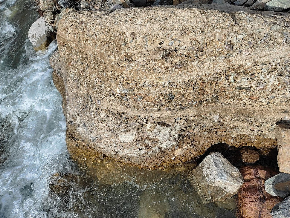
What is this it's looks like stone but it's layer of soil and stone mixture. I live in himalayan region of india...

High energy granular particle signature with breccia and vesicles a gassing effect like cinders. This is similar to the shock produced chopstick agate but the shock circle form is clearly indicating a shift from fractal tree to a higher order energy dispersion signature.

This is the state before suev

Ries Crater Suevite.

Sudbury Crater Suevite.
.jpg)
Went to Don Bosco High School, Dibrugarh
Lives in Naharlagun, India
Melt wave mega clast. This type of wave form is a sheet wave like you see on the ocean.

Coning Reversal >>>
Mt. Everest as seen from plane.
.jpg)

The lapis mines of Afghanistan are a crater wall vein deposit of the Himalayan Impact.

These Afghanistan lapis slabs are highly metamorphic and multi mineral blends characteristic of impact.

Geomorphological Features
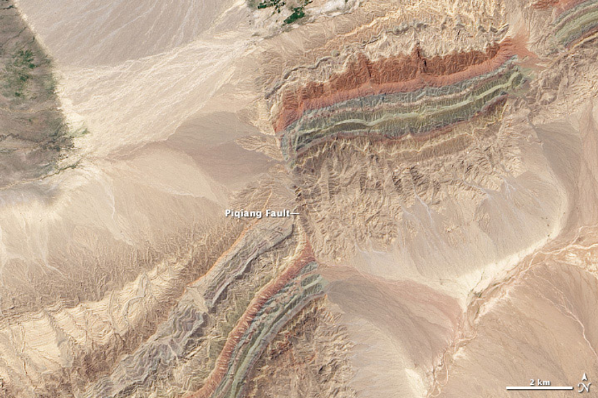
Satellite image of the Piqiang Fault, a northwest trending left-lateral strike-slip fault in the Taklamakan Desert south of the Tian Shan Mountains, China (40.3°N, 77.7°E). (credit: NASA Earth Observatory images)
This geologic feature is the NW side of the Himalayan Impact. The earth is still resolving this stress. You can see the fractal construction of the earth in this zone as it was made with a very high energy. The minerals from the protoplanet have separated in the refining nature of the explosion plasma resonate event.

Himalayas from space. Earth craters. You can see the sinusoidal crater wall waves with other later impacts some quite large as viewed from space even. The Himalaya impact was a type 2 subduction. This is often confused with Raft/Plate tectonics. The mechanism of Raft/Plate tectonics cannot make circles or arcs. It is a shadow theory like Plato's cave. Did the Himalaya impact cause the Deccan Traps? No, however the Earth has sustained many large accretion impacts. May 5, 2024.

Science at home. Take two sheets of aluminum foil and push them together. Try as you will, you will not make circles or arcs. I used to be a bending engineer, circles and arcs require a die or form to circular fold in the colliding axis. You can make sign waves but that will not be in the earth's surface plane, nor will it be an arc as seen in the Himalayas. Fossils on mountain tops is the same as Raft/Plate tectonics they were pushed or blasted up from the impact floor. Does impact tectonics have boundary collision? Yes, like the Moon or Mars you can deform craters with other impacts. Remember building crater walls is an inversion process with deeper strata excavated to the crater rims. May 5, 2024.
John Zoidberg
At the summit of Mount Everest, marine limestone and fossils of cephalopods, trilobites, brachiopods were discovered, indicating that at some point the highest point on Earth was under the sea.

The Kunlun Mountains are a second large crater. May 5, 2024.

The Kunlun Mountains Crater Complex. Multiple overlapping impacts made connections but not pretty simple circles. Nor do big earth impacts tend to make circles as the relative size of earth and the impact physics are different for larger sizes. The larger the impact the more it will show impact angle. May 5, 2024.

Impact ash at the base with Mountains as the up force from the impact. May 10, 2024.
Archaeology and Ancient World ·
The Karakoram Highway, connecting Pakistan to China, is one of the highest paved roads in the world, at maximum elevation of 4,714 m.
It is often referred to as the Eighth Wonder of the World.

Swiss Alps from space. Like the Himalaya crater structure you have inter crater impacts. As you can see the larger ones are deeper as an impact goes down a crater radius with the bigger ones causing impact volcanics as they are crust breakers called Crusta Confractus.

Waffle iron triangle coning in the Swiss Alps. Not an up splash cone type as it is a fractal type therefore a harmonic. This view shows the contrast of a crater floor to a crater wall. The floor does get flattened out over time as debris accumulates. 29 April 2026.

Impact has a statistical propensity to make vertical strata as shown here. Impact tectonics includes the up-splash effect whereas the antiquated raft/plate tectonics would only tend to make a crumpled surface. Now notice the tube up splash that is a liquid type of stream not a feature at all of crashing plates. In many ways the raft/plate tectonics theory is a perfect example of Plato's cave a reflection reality with the actual event lost in a smoky viewing.
Geo Lens
March 4 ·
Breathtaking view of the Alpstein mountain range in Switzerland.
29 April 2026.

Plato's cave shown above. Raft/plate tectonics which I call the weatherman theory is based on a gas/liquid model which made perfect sense to the weatherman who came up with it. Actual earth surface features are just like you can see on the moon or mars. They may or may not have a liquid core it really does not matter as they certainly have solid crust with craters as the dominate shaper of the surfaces. On earth failure to find craters does not equate to failure to exist. For example, I spent six years exploring and mapping the Howell, TN Impact Structure and following the evidence showed its features whereas geologist in 85 years accomplished noting of any merit. They were and still are stuck in an antiquated system of understanding. 29 April 2026.

Let me show you what floating hard surface crustal raft/plate collisions would look like.

Unless starting with arcs and circles this is what that crash looks like.

You can have overlapping plates with a huge disconformity and slanted strata but I don't see any vertical results. 29 April 2026.

So, what if you model a non-uniform crustal collision cracking system? See many curves, arcs, round pieces? Remember the whole raft/plate tectonics system is just an idea with artist made drawings of it. It certainly fails the try it at home kitchen test. 29 April 2026.

So now geology believes crust is missing from the collision of India with Asia. This is just really poor forensics. It is like showing up at a wreck and saying the building hit the car. You just cannot make an arc collision that way. The missing crust was subducted but by a type 2 subduction crater coming in from the NE. Besides that, you can see other craters by just looking for the circles and arcs, impact tectonics instead of raft/plate tectonics. 3 July 2026.
Case of Earth’s Missing Continental Crust Solved: It Sank
Mantle swallowed massive chunk of Eurasia and India, study finds
4-Oct-2016 at 6:05 PM EDT, by University of Chicago
Newswise —
How do you make half the mass of two continents disappear? To answer that question, you first need to discover that it’s missing.
That’s what a trio of University of Chicago geoscientists and their collaborator did, and their explanation for where the mass went significantly changes prevailing ideas about what can happen when continents collide. It also has important implications for our understanding of when the continents grew to their present size and how the chemistry of the Earth’s interior has evolved.
The study, published online Sept. 19 in Nature Geoscience, examines the collision of Eurasia and India, which began about 60 million years ago, created the Himalayas and is still in (slow) progress. The scientists computed with unprecedented precision the amount of landmass, or “continental crust,” before and after the collision.
“What we found is that half of the mass that was there 60 million years ago is missing from the earth’s surface today,“ said Miquela Ingalls, a graduate student in geophysical sciences who led the project as part of her doctoral work.
The result was unexpectedly large. After considering all other ways the mass might be accounted for, the researchers concluded that so huge a mass discrepancy could only be explained if the missing chunk had gone back down into the Earth’s mantle—something geoscientists had considered more or less impossible on such a scale.
When tectonic plates come together, something has to give. According to plate tectonic theory, the surface of the Earth comprises a mosaic of about a dozen rigid plates in relative motion. These plates move atop the upper mantle, and plates topped with thicker, more buoyant continental crust ride higher than those topped with thinner oceanic crust. Oceanic crust can dip and slide into the mantle, where it eventually mixes together with the mantle material. But continental crust like that involved in the Eurasia-India collision is less dense, and geologists have long believed that when it meets the mantle, it is pushed back up like a beach ball in water, never mixing back in.
Geology 101 miscreant
“We’re taught in Geology 101 that continental crust is buoyant and can’t descend into the mantle,” Ingalls said. The new results throw that idea out the window.
“We really have significant amounts of crust that have disappeared from the crustal reservoir, and the only place that it can go is into the mantle,” said David Rowley, a professor in geophysical sciences who is one of Ingalls’ advisors and a collaborator on the project. “It used to be thought that the mantle and the crust interacted only in a relatively minor way. This work suggests that, at least in certain circumstances, that’s not true.”
The scientists’ conclusion arose out of meticulous calculations of the amount of mass there before and after the collision, and a careful accounting of all possible ways it could have been distributed. Computing the amount of crust “before” is a contentious problem involving careful dating of the ages of strata and reconstructions of past plate positions, Ingalls said. Previous workers have done similar calculations but have often tried to force the “before” and “after” numbers to balance, “trying to make the system match up with what we think we already know about how tectonics works.”
Ingalls and collaborators made no such assumptions. They used recently revised estimates about plate movements to figure out how large the two plates were at the onset of collision, and synthesized more than 20 years’ worth of data on the geology of various regions of the Earth to calculate how thick the crust would have been.
“By looking at all of the relevant data sets, we’ve been able to say what the mass of the crust was at the beginning of collision,” Rowley said.
Limited options
There were only a few places for the displaced crust to go after the collision: Some was thrust upward, forming the Himalayas, some was eroded and deposited as enormous sedimentary deposits in the oceans, and some was squeezed out the sides of the colliding plates, forming Southeast Asia.
“But accounting for all of these different types of mass loss, we still find that half of the continental crust involved in this collision is missing today,” Ingalls said. “If we’ve accounted for all possible solutions at the surface, it means the remaining mass must have been recycled wholesale into the mantle.”
If large areas of continental crust are recycled back into the mantle, scientists can at last explain some previously puzzling geochemistry. Elements including lead and uranium are periodically erupted from the mantle through volcanic activity. Such elements are relatively abundant in continental crust, but scarce in the mantle. Yet the composition of some mantle-derived rocks indicates that they have been contaminated by continental crust. So how did continental material mix back into the mantle?
“The implication of our work is that, if we’re seeing the India-Asia collision system as an ongoing process over Earth’s history, there has been a continuous mixing of the continental crustal elements back into the mantle,” said Rowley. “And they can then be re-extracted and seen in some of those volcanic materials that come out of the mantle today.”
Citation: “Large-scale subduction of continental crust implied by India-Asia mass-balance calculation,” by Miquela Ingalls, David B. Rowley, Brian Currie, and Albert S. Colman, Nature Geoscience, published online Sept. 19, 2016, doi:10.1038/ngeo2806
Funding: National Science Foundation
